Tropical Depression Five Advisory Number 1
NWS National Hurricane Center Miami FL Al052019
1100 Am AST Sat Aug 24 2019
…New Tropical Depression Forms East-Southeast Of The Lesser Antilles…
Summary of 1100 Am Ast…1500 UTC…Information
———————————————–
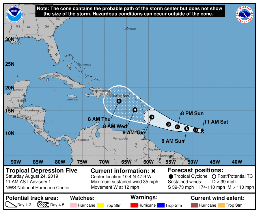
Location…10.4n 47.9w About 805 Mi…1300 Km ESE Of Barbados Maximum Sustained Winds…35 Mph…55 KM/H Present Movement…W or 280 Degrees At 12 Mph…19 KM/H Minimum Central Pressure…1010 Mb…29.83 Inches
Watches And Warnings
——————–
There Are No Coastal Watches Or Warnings In Effect.
Interests In The Central And Northern Lesser Antilles Should Monitor The Progress This System.
Discussion And Outlook
———————-
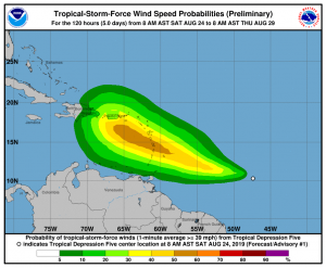
At 1100 Am AST (1500 UTC), The Center Of Newly Formed Tropical Depression Five Was Located Near Latitude 10.4 North, Longitude 47.9 West. The Depression Is Moving Toward The West Near 12 Mph (19 Km/H) And This General Motion Is Expected To Continue Today.
A Turn Toward The West-Northwest Is Forecast On Sunday, And That Motion Is Expected To Continue Through Tuesday. On The Forecast Track, The Tropical Cyclone Is Expected To Be Near The Central Lesser Antilles On Tuesday.
Maximum Sustained Winds Are Near 35 Mph (55 Km/H) With Higher Gusts. Gradual Strengthening Is Forecast During The Next Few Days, And The Depression Is Forecast To Become A Tropical Storm Later Tonight Or On Sunday.
The Estimated Minimum Central Pressure Is 1010 Mb (29.83 Inches).
Hazards Affecting Land
———————-
None.
Next Advisory
————-
Next Complete Advisory At 500 Pm Ast.


Forecaster Stewart