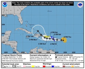
Weather Update: Fiona’s centre of circulation has a small area of thunderstorms near its east, and the larger mass of thunderstorms further east have shifted a bit south and southwest. The centre has also been moving south of west or 260 degrees which means it has lost latitude compared to earlier in the day. It looks like it is moving along 16.1N directly east of Guadeloupe.
As I mentioned earlier, the heavy rainfall potential for Dominica [Guadeloupe is a higher chance] needs to be watched and it looks like the probability has increased. It is not necessarily the same setup as Erika, but I can tell you there are some eerie similarities. Center projected to pass over/north of Guada, no TS watch or warning for Dominica. Wind shear causing heaviest thunderstorms to form down shear(opposite direction from where shear is coming from) which is east and SE in this case (shear direction is W to WNW and even NW at mid-levels) in Erika heaviest formed more SE to S of center because the shear direction was from WNW to NW. With Fiona mid-level shear is being analyzed from the WNW and NW and this is pushing the mid-level vorticity/spin to the SE of Fiona
Tropical Storm Warning is in effect for –
Antigua and Barbuda, Anguilla, St Kitts and Nevis, Montserrat and
Saba and St Eustatius
St Maarten
Guadeloupe, St Barthelemy, and St Martin
As per the experts, a Tropical Storm Watch is in effect for –
Puerto Rico, including Vieques and Culebra
U.S. Virgin Islands