By Caribbean News Now contributor
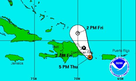
MIAMI, USA — Tropical depression Gabrielle, now barely a cyclone, was expected to degenerate into a remnant low pressure area on Thursday night or Friday as the centre passes near or over the eastern Dominican Republic. There are no coastal watches or warnings in effect; however, interests in Hispaniola, Puerto Rico, the southeastern Bahamas and the Turks and Caicos Islands should monitor the progress of this system.
According to the National Hurricane Center in Miami, at 5:00 pm EDT on Thursday, the centre of tropical depression Gabrielle was located about 30 miles south-southwest of Punta Cana in the Dominican Republic and moving toward the northwest near 9 mph. A gradual turn toward the north-northwest is expected during the next 24 hours or so. Maximum sustained winds are near 30 mph, with higher gusts.
Gabrielle is expected to produce total rainfall amounts of 2 to 4 inches over Puerto Rico and the US Virgin Islands, with isolated maximum amounts of up to 8 inches possible in areas of mountainous terrain. These rains could cause dangerous flash floods and mud slides over mountainous terrain.
Meanwhile, a large area of disorganized showers and thunderstorms associated with a surface trough extends from the northern Leeward Islands near tropical depression Gabrielle northward over the Atlantic waters for several hundred miles. Any development of this system is expected to be slow due to strong upper-level winds. This system has a low chance (20 percent) of becoming a tropical cyclone during the next 48 hours as it moves northwestward at 10 to 15 mph. Some development could also occur in a few days when the system moves northeastward ahead of a cold front over the central Atlantic ocean. This system has a medium chance (30 percent) of becoming a tropical cyclone during the next five days.
Another tropical wave located about 500 miles west-southwest of the Cape Verde Islands is producing a large area of cloudiness and showers. Development, if any, is expected to be limited due to dry air, and environmental conditions are forecast to become very unfavourable in a couple of days. This system has a low chance (10 percent) of becoming a tropical cyclone during the next five days while it moves to the west-northwest at about 10 mph.
Satellite data and surface observations also indicate that a broad area of low pressure has formed over the southwestern Gulf of Mexico about 200 miles east of Tampico, Mexico. Showers and thunderstorms are showing signs of organization and a tropical depression could form before the low moves inland along the coast of Mexico on Friday. This system has a medium chance (50 percent) of becoming a tropical cyclone during the next five days. An air force reserve reconnaissance aircraft was en route to investigate the system.
At the same time, a tropical wave over Africa is expected to move over the far eastern Atlantic Ocean in a couple of days and development of this system is possible over the weekend into early next week. This system has a medium chance (30 percent) of becoming a tropical cyclone during the next five days.