– Tropical Storm Bertha to affect Windward Islands Friday, Puerto Rico, Virgin Islands and the Dominican Republic Saturday.
– Bertha expected to then track through the southeast Bahamas Sunday.
– Bertha threats: Locally heavy rain/flash flooding, some strong wind gusts, rip currents.
– A U.S. threat appears unlikely, but can’t be completely ruled out yet.
Tropical Storm Bertha formed late Thursday night, about 275 miles east-southeast of Barbados and is now tracking quickly toward the Windward Islands.
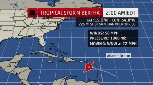
As of Friday evening (local time), Bertha was located about 40 miles west-southwest of Dominica, and 355 miles southeast of San Juan, Puerto Rico. Tropical storm warnings are now in effect for Puerto Rico, the U.S. and British Virgin Islands and parts of the Windward Islands (see below).
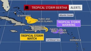
A tropical storm watch is issued when those conditions are possible within the area. Watches are typically posted 48 hours in advance of the onset of tropical storm-force conditions, since preparing for the storm becomes difficult once tropical storm-force winds begin. A tropical storm warning means those conditions are expected in the area. Warnings are typically issued 36 hours in advance of the onset of tropical storm-force winds. When a warning is issued, you should complete all storm preparations and, if directed by local officials, evacuate the area immediately.
Tropical storm-force winds (sustained wind speeds of 39 mph or greater) are expected to spread into the warned areas of the Windward Islands Friday, then may arrive in Puerto Rico and the Virgin Islands on Saturday.
Bertha is expected to track near the Dominican Republic Saturday night into early Sunday, then the southeast Bahamas Sunday.
An area of low pressure aloft (called a tropical upper tropospheric trough or TUTT) is interacting with the tropical storm, producing wind shear (change in wind direction and/or speed with height) that is hostile for tropical cyclone intensification.
Bertha is also battling an atmosphere of dry air, also hostile for intensification, and its circulation may be further disrupted by passage over parts of Puerto Rico and possibly the Dominican Republic this weekend.
Therefore, the official forecast does not expect significant intensification of Bertha through at least early Sunday. In fact, it’s possible Bertha may degenerate to a tropical wave anytime this weekend.

This infrared satellite image shows how cold (and therefore how high) the cloud tops are. Brighter orange and red shadings concentrated near the center of circulation signify a healthy tropical cyclone.
Bertha may produce rainfall amounts of 1 to 3 inches across portions of the Leeward Islands, Puerto Rico, and the U.S. Virgin Islands. Isolated totals up to 10 inches are possible over the higher terrain of southern Puerto Rico. While Bertha’s rain will eventually prove beneficial with regards to the developing drought, too much rain too fast will also create hazardous flooding and mudslide conditions.
(FORECASTS: Guadeloupe | St. Thomas | San Juan)
Speaking of the Caribbean drought, through Wednesday, the Cyril E. King Airport on St. Thomas in the U.S. Virgin Islands had only picked up 0.89 inches of rain since June 1, just under 17 percent of the average rainfall during that period (5.28 inches).
Is Bertha a U.S. Threat?
Assuming Bertha holds together in the marginal environment near the Lesser Antilles, Virgin Islands and Puerto Rico, there is some potential for strengthening early next week if wind shear aloft relaxes and the surrounding air mass moistens up.
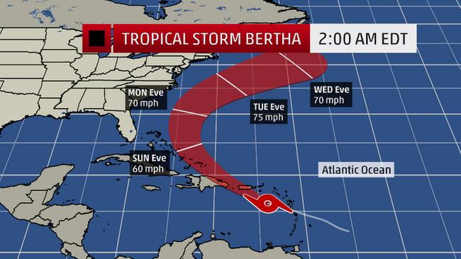
The majority of our forecast guidance suggests steering currents in the upper atmosphere (a southward dip in the jet stream carving into the southeast U.S.) should turn the system north then northeast away from the East Coast during the first half of next week. For now, it appears the center of Bertha may pass sufficiently to the west of Bermuda to avoid significant impacts later Tuesday or Wednesday.
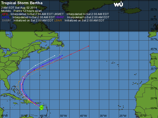
Model forecast tracks of Bertha, via Weather Underground.
MODEL FORECAST INTENSITY
However, this forecast could change. Interests along the Southeast U.S. coast and Bermuda should continue to monitor the progress of Bertha.