Terry Ally
(news@caribbean360.com)
BRIDGETOWN, Barbados, Thrusday August 15, 2013 – Overnight a new tropical storm formed in the Atlantic while a second is on the verge of developing by the weekend.
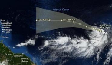
Tropical Storm Erin formed in the far eastern Atlantic Ocean south-east of the Cape Verde Islands where a tropical storm warning is in effect for the islands of Maio, Santiago, Fogo and Brave.
Hurricane Specialist Robbie Berg at the National Hurricane Centre in Miami says that Erin is located in an area that favours further strengthening, becoming the fifth named storm of the 2013 Atlantic Hurricane season early Thursday morning, according to Senior Hurricane Specialist Dr Jack Beven.
Erin is expected to take a track through the central Atlantic Ocean before weakening next week as it travels over cooler storm-killing waters. It should pose no threat to the Caribbean islands, tourists or holiday makers.
On the other side of the Atlantic, in the south-west Caribbean Sea a tropical disturbance has successfully travelled through the infamous “hurricane graveyard” but in a weak condition.
Science and Operations Officer Dr Chris Landsea of the Technology & Science Branch of the National Hurricane Centre says that showers and thunderstorm activities associated with the low pressure system, now in the northwestern Caribbean Sea, have decreased.
“Conditions are conducive for development and a tropical cyclone could develop in the next few days … this system has a medium chance – 50 per cent – of becoming a tropical cyclone during the next 48 hours,” Landsea adds.
If it does become a tropical storm it will be named Fernand. The majority of Computer tracking models take Fernand into Mexico.
Global forecasters are predicting a higher than normal active Atlantic Hurricane season – which runs from June 1 to November 30. The National Hurricane Centre has forecast 13 to 19 storms. Philip Klotzbach and Professor Bill Gray of Colorado State University are predicting 18 storms while the Tropical Storm Risk and UK Met Office are both forecasting 14 storms. The historical average (1981-2010) is 12 storms.
The period when the Caribbean is most at risk is the 60-day period starting today 15 August through to mid-October.
Probability forecast by Klotzback and Gray (http://typhoon.atmos.colostate.edu/forecasts/2013/aug2013/aug2013.pdf) shows that the Caribbean islands most at risk for the remainder of the year are The Bahamas, Cuba, Haiti, Jamaica, Puerto Rico, Turks and Caicos and US Virgin Islands.