AccuWeather: Interests in the Windward Islands and along the northern coast of South America should monitor the progress of Gonzalo. If the system holds together, an uptick in showers and thunderstorms would occur in the Windwards beginning Friday night and will spread westward over the southeastern part of the Caribbean during the weekend.
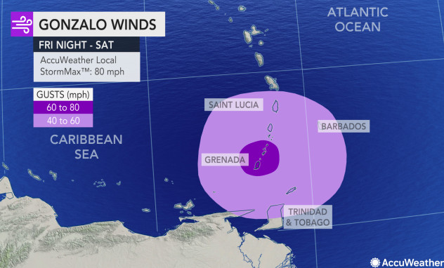
“The AccuWeather RealImpact™ Hurricane Scale for Gonzalo on the Windward Islands is estimated to be a one since the storm may still be close to hurricane strength upon arrival,” Miller said.
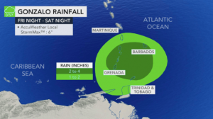
Conditions over the islands may vary from needed rainfall to flash flooding and mudslides. A general 2-4 inches (50-100 millimeters) of rain is forecast with an AccuWeather Local StormMax™ of 6 inches (150 millimeters) anticipated.
Seas will build late in the week due to the storm’s approach with a minor to moderate storm surge anticipated.
While the exact conditions will depend on the track and strength of the small system, at this time islands from Grenada and Saint Vincent and the Grenadines may have the most substantial impact from Gonzalo. These aforementioned islands stand the best chance of strong tropical storm to hurricane-force wind gusts, which could trigger power outages.
Once the behavior of the system becomes established near the Windwards, a more definitive impact on the balance of the Caribbean can be determined. Steering breezes would likely take Gonzalo on a general west to northwest path later this weekend and early next week. As a result all interests in the Caribbean should monitor the progress of the storm.
National Hurricane Center: At 500 PM AST (2100 UTC), the center of Tropical Storm Gonzalo was located near latitude 9.9 North, longitude 45.0 West. Gonzalo is moving toward the west near 14 mph (22 km/h). A general westward motion at a faster forward speed is expected during the next few days. On the forecast track, the center of Gonzalo would approach the Windward Islands late Friday and Saturday.
Maximum sustained winds are near 50 mph (85 km/h) with higher gusts. Strengthening is forecast during the next couple of days, and Gonzalo is expected to become a hurricane by Thursday.
Gonzalo is a small tropical cyclone, as tropical-storm-force winds extend outward up to 35 miles (55 km) from the center.
The estimated minimum central pressure is 1000 mb (29.53 inches).