GEORGETOWN (CMC):
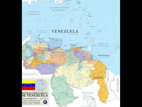
Foreign Secretary Robert Persaud has written social media giants Facebook and Twitter asking that false maps of Guyana posted by pro-Venezuelan interests be removed from the social media platforms.
According to a statement issued by the government on Thursday, Persaud’s correspondence was sent in light of “a renewed orchestrated disinformation campaign being waged against Guyana by a number of Spanish-language social media accounts claiming Guyana’s territory by publishing illegal maps”.
In his letters, Persaud said the social media operatives had been using Facebook and Twitter to propagate a false narrative regarding the controversy between Guyana and Venezuela about the validity of the 1899 Arbitral Award, which settled the land boundary between Guyana and Venezuela.
“I wish to point out that Facebook (and Twitter) posts and the subsequent comments surrounding the particular posts have the potential to permanently damage relations between states, incite violence against the territory and people of Guyana, and derail the current adjudication of the matter before the International Court of Justice (ICJ),” Persaud said, noting that the boundary and the corresponding territory of Guyana are internationally recognised, including by the United Nations.
“In this regard, I am requesting that these types of Facebook posts (and Twitter), which violate the basic tenet of international relations between states, the sovereignty and territorial integrity of the Cooperative Republic of Guyana and incite a threat of use of force against Guyana, be removed forthwith and more stringent measure be taken against their publications,’’ the foreign secretary’s letter urged.
The land boundary between Guyana and Venezuela was settled by a legal process of International Arbitration on October 3, 1899, pursuant to an 1897 Treaty of Washington by which both parties agreed to respect the results of the arbitration as a full, perfect and final settlement of the boundary. At that time, Guyana was British Guiana, a colony of Great Britain.
As required by the 1897 Treaty of Washington and the 1899 Arbitral Award, the boundary as determined by the award was demarcated on the ground between 1900 and 1904 by commissioners appointed by Britain and Venezuela.
On January 7, 1905, the official boundary map delineating the boundary as awarded and demarcated, was drawn up and signed by the commissioners of both Britain and Venezuela and promulgated in Georgetown, at the Combined Court.
However, Venezuela subsequently disputed the validity of the 1899 Arbitral Award. The long-standing row is currently before the ICJ, following an application submitted by Guyana on March 29, 2018.
The court confirmed its jurisdiction over Guyana’s claims, rejecting Venezuela’s objections, in a judgment issued on December 18, 2020, which means that the ICJ will be the court that decides, with final and binding effect on both parties, whether the 1899 Arbitral Award was lawfully issued and remains legally valid and permanently binding as a matter of international law.